The research team has identified traces of climate instability in outcrops on Mount Sharp, at Mars’ equator. These traces point to the red planet transitioning about 3 billion years ago from a wetter to a drier climate before reverting to a wet environment. These alternating wet and dry periods are visible for several hundred metres in the geological strata on Mount Sharp, indicating that the phenomenon likely spanned several million years. The sedimentary bedding structures, imaged for the first time from the Martian surface, bear the marks of ancient changes in climate revealing not just one but at least two large-scale transitions.

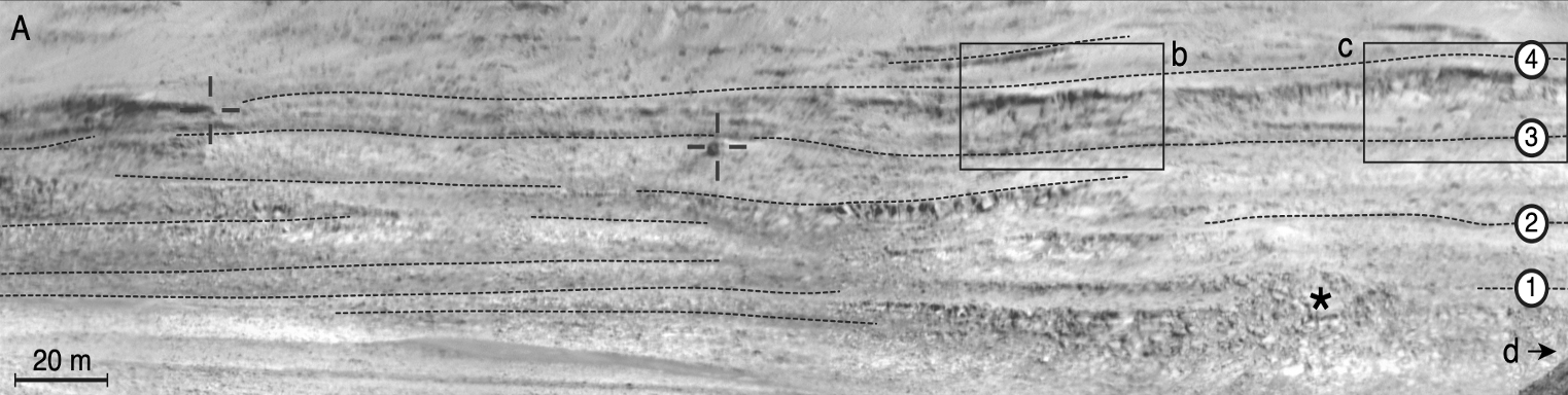
The way sedimentary deposits are organized, their facies and structure give indications about Mars’ ancient climate. This image was taken at the heart of Mount Sharp with the ChemCam instrument’s Mastcam colour cameras on the Curiosity rover.
© NASA/JPL-Caltech/MSSS/CNES/CNRS/LANL/IRAP/IAS/LPGN
Mars in high resolution
William Rapin is the lead author of the article published in the review Geology confirming the hypothesis formulated from orbital measurements that Mars transitioned to a drier environment. From orbit, analysis of light reflected by the planet’s surface indicates changes in mineralogy—from clay-bearing to sulphate-bearing layers—in several places, which are the sign of an environmental transition. It is precisely to investigate such mineral transitions that Mount Sharp was chosen as the landing site for Curiosity in 2012. Among the rover’s ten instruments, the French ChemCam built with CNES’s support has a high-resolution RMI (Remote Micro-Imager) camera for observing rocks.
RMI’s ability to acquire images with a resolution better than 10 cm from a stand-off distance of several kilometres has revealed alternating structures in sedimentary rock layers. Rock structure tells us in what kind of environment sediments were deposited. The rover has observed successions of thin planar layers at the base of Mount Sharp, interpreted as the mark of a lacustrine environment (image A below). At 350 metres above this marker bed, RMI has revealed cross-bedding structures typical of aeolian deposits, in other words of a dry environment (images E to G). “This initial observation was vital for our mission,” says Rapin, who had just confirmed with in-situ readings a hypothesis based on mineral compositions measured from orbit. But that’s not the end of the story...

Caption:
- A - In this image of Mont Sharp taken by the rover’s Mastcam colour cameras, geologists have bounded areas of scientific interest.
- B - D: Zones 2B, 2C and 2D were imaged with the RMI camera at 10-cm resolution.
- E - G: In these 3 zones, cross-bedding consistent with aeolian deposits is underlined in red.
- a: In zone 4, sediment layers form linear, planar deposits shown by dashed blue lines, consistent with a fluvial origin.
At least two climate transitions
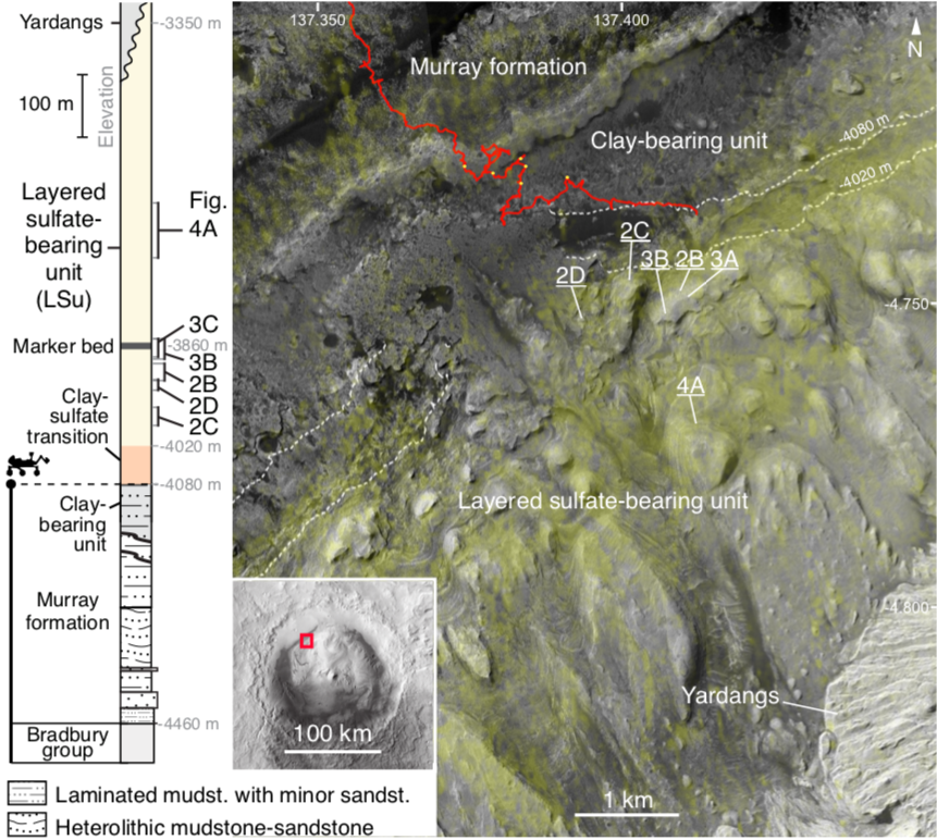
Mount Sharp seen by the HiRISE instrument from orbit, showing Curiosity’s traverse (red) and locations from which RMI images were acquired (yellow dots).
“We had a surprise when we pointed our camera higher up, 200 metres above the cross-bedding structures,” explains Rapin. “We found sedimentary structures of a completely different nature in buttes almost 5 kilometres away. These alternating resistant and brittle planar deposits reflect a fluvial environment, in particular that of a flood plain. This suggests a return to a wetter environment after the dry period. The research team not only confirmed a change in the climate; they also identified a second climate transition within the same geological era.”
Until now, all the evidence pointed to the planet having evolved from a wet to a dry climate in a single transition. This model was of course based on the mineral transition and on large-scale erosion structures visible from orbit, like for example river valleys. In fact, volcanism or other phenomena must have erased finer surface traces while sedimentary deposits like those on Mount Sharp have preserved the climate record. “The alternating sedimentary structures have enabled us to overturn the established model according to which Mars dried in monotonic fashion,” says Rapin.
What caused these fluctuations remains something of a mystery, but their extent—since they occurred over at least a million years and almost certainly longer—suggests global phenomena, possibly episodic volcanism, variations in the obliquity, precession or eccentricity of Mars’ orbit, or a disruption of its main geochemical cycles, which, if we take Earth as a model, could be due to life evolving... The research team is counting on the rover, which is now climbing up through 500 metres of sedimentary layers, to provide some answers.
Contacts
- William Rapin
Research scientist at IRAP-CNRS (UMR 5277) - Paul Sabatier University.
9 Avenue du Colonel Roche, 31400 Toulouse
E-mail : william.rapin at irap.omp.eu
Tel. : +33 (0)7 69 58 42 56
- Francis Rocard
Head of Planets and Small Solar System Bodies, CNES
Centre National d'Etudes Spatiales 2 place Maurice Quentin 75039 Paris Cedex 01, France
E-mail : francis.rocard at cnes.fr
Tel. : +33 (0)1 44 76 75 98